What Is an Aerodrome? The Complete Guide for Canadian Drone Pilots (2026)
A Deep Dive Into Aerodromes, Airspace, and Legal Drone Operations in Canada
If you’re flying drones in Canada—especially at the Advanced level—understanding what an aerodrome is goes far beyond just passing an exam.
It directly impacts:
- Where you can legally fly
- How you plan your missions
- How you assess risk
- Whether you pass a Transport Canada flight review
Yet, despite its importance, “aerodrome” is one of the most misunderstood terms among drone pilots.
In this comprehensive guide, we’ll break down everything you need to know—from legal definitions to real-world scenarios—so you can operate safely and confidently under Transport Canada regulations.
What Is an Aerodrome? (Official Canadian Definition)
According to the Canadian Aviation Regulations (CARs), an aerodrome is:
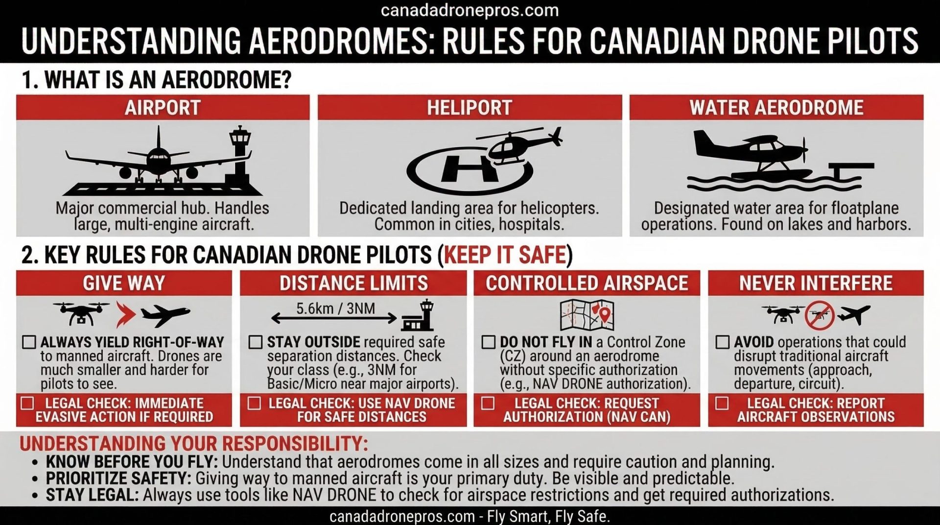
Any area of land, water, or ice used, designed, prepared, or set apart for the arrival, departure, movement, or servicing of aircraft.
This definition is intentionally broad—and that’s exactly why it matters.
Why This Definition Is So Important
Most new drone pilots think:
“Aerodrome = airport”
That assumption is wrong—and potentially dangerous.
Because in reality, an aerodrome includes:
- International airports
- Small rural airstrips
- Private landing strips
- Helicopter landing zones
- Lakes used by seaplanes
- Temporary or seasonal landing areas
If an aircraft can take off or land there—it may legally qualify as an aerodrome.
Aerodrome vs Airport: A Critical Distinction
Understanding the difference between these two terms is essential.
Aerodrome (Broad Category)
- Any place aircraft can operate from
- May be registered or unregistered
- May not appear on maps or apps
- May not have any infrastructure
Airport (Specific Type of Aerodrome)
- Certified under strict regulations
- Listed in official aviation publications
- Typically has:
- Runways
- Lighting
- Markings
- Air traffic procedures
Simple Rule to Remember
All airports are aerodromes—but not all aerodromes are airports.
For drone pilots, this means:
- You must think beyond major airports
- Risk exists in far more places than you expect
Types of Aerodromes in Canada
Let’s break this down into categories you’ll actually encounter in the field.
1. Certified Airports
These are the most obvious and regulated aerodromes.
Examples:
- Vancouver International
- Calgary International
- Prince George Airport
Characteristics:
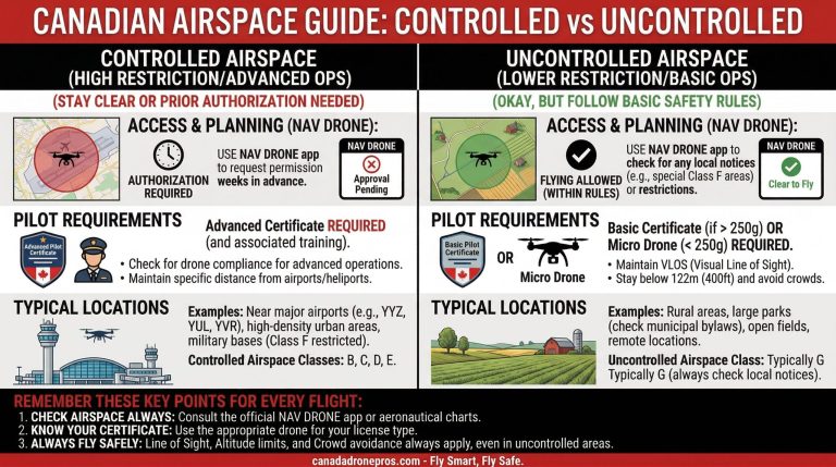
- Controlled airspace (Class C or D)
- Air Traffic Control (ATC)
- Clearly defined control zones
These are always visible in tools like NAV Drone.
2. Registered Aerodromes
These are officially recognized but not certified.
They may include:
- Small regional airports
- Rural airstrips
Characteristics:
- Listed in aviation databases
- May not have ATC
- Often located in uncontrolled airspace
3. Unregistered Aerodromes (High Risk for Drone Pilots)
This is where many pilots get caught off guard.
These include:
- Private airstrips
- Logging or mining company landing areas
- Agricultural fields used for aircraft
- Remote gravel strips
Important:
- These may NOT appear in NAV Drone
- They may NOT appear on charts
But they are still legally aerodromes.
4. Heliports and Helipads
Used by:
- Medevac services
- Oil & gas operations
- Urban emergency services
These are particularly dangerous because:
- Helicopters operate at low altitude
- They can change direction quickly
- They may appear with little warning
5. Seaplane Bases
Extremely common in British Columbia.
Located on:
- Lakes
- Rivers
- Coastal areas
Why they matter:
- Aircraft operate at very low altitude
- Water surfaces may appear “empty” but are active
Why Aerodromes Matter for Drone Pilots
Understanding aerodromes is not just theoretical—it directly affects your operations.
1. Collision Risk
Aircraft operate at:
- Low altitudes during takeoff and landing
- The same altitude range as drones
This creates a high-risk environment.
2. Legal Compliance
Under Transport Canada, you must:
- Avoid interfering with aircraft
- Yield to all manned aviation
- Follow airspace restrictions
3. Airspace Classification
Aerodromes often determine:
- Control zones
- Airspace class
For example:
- Class C around major airports
- Class D around smaller ones
Canadian Drone Laws Around Aerodromes
Let’s break this down clearly.
Basic Operations
You must stay:
- 3 nautical miles from airports
- 1 nautical mile from heliports
No exceptions.
Advanced Operations
You CAN fly closer—but only if:
- You receive authorization
- You operate safely
- You follow all conditions
Universal Rule
Regardless of license level:
You must always yield to manned aircraft.
How to Identify Aerodromes Before a Flight
This is a critical flight planning skill.
1. Use NAV Drone
NAV Drone shows:
- Major aerodromes
- Control zones
- Airspace classifications
But remember:
- It does NOT show everything
2. Use Aeronautical Charts
VFR Navigation Charts (VNC) provide:
- Registered aerodromes
- Terrain and obstacles
3. Use Satellite Imagery
Tools like:
- Google Maps
- Google Earth
Help identify:
- Runways
- Clearings
- Water landing zones
4. Check NOTAMs
NOTAMs may indicate:
- Temporary aerodromes
- Increased aircraft activity
5. Conduct a Physical Site Survey
Look for:
- Aircraft activity
- Landing areas
- Helicopter traffic
Real-World Scenario (Northern BC)
Let’s make this practical.
You’re hired to film a forestry operation near Dawson Creek.
You check NAV Drone:
- No major airport nearby
- Airspace appears clear
But in reality:
- A helicopter is servicing the site
- A nearby clearing is used as a landing zone
This is effectively an unregistered aerodrome environment.
What a Professional Pilot Does
- Recognizes the risk
- Adjusts flight altitude
- Maintains constant awareness
- Prepares for immediate descent
How Aerodromes Appear in a Flight Review
Flight reviewers care deeply about this topic.
Typical Question
“What aerodromes are in this area?”
Weak Answer
“There’s no airport nearby.”
Strong Answer
“NAV Drone shows a registered aerodrome nearby. Additionally, given the environment, there may be unregistered landing areas or helicopter activity, so I will maintain heightened awareness.”
That answer demonstrates:
- Knowledge
- Risk awareness
- Professional thinking
Advanced Risk Management Near Aerodromes
1. Establish Buffers
Even if legal:
- Stay farther away than required
2. Fly Lower
Reduce conflict with aircraft
3. Use a Visual Observer
Especially in high-risk environments
4. Listen Constantly
Aircraft are often heard before seen
5. Plan Emergency Actions
Always know:
- Where to descend
- Where to land
Common Mistakes Drone Pilots Make
1. Only Looking for Airports
Ignoring smaller aerodromes
2. Over-Relying on Apps
Not all aerodromes appear digitally
3. Ignoring Helicopters
Major safety risk
4. Not Conducting Site Surveys
Missing real-world hazards
Frequently Asked Questions (SEO Optimized)
Do all aerodromes appear in NAV Drone?
No. Many private or temporary aerodromes do not.
Can I fly near an aerodrome with an Advanced license?
Yes, with proper authorization and risk management.
Are lakes considered aerodromes?
If used by seaplanes—yes.
Do I need permission to fly near all aerodromes?
Not always—but you must never interfere with aircraft.
What is the safest practice near aerodromes?
Maintain distance, stay low, and stay alert.
Final Thoughts
Understanding aerodromes is one of the most important skills for Canadian drone pilots.
It separates:
- Hobbyists from professionals
- Safe pilots from risky ones